How Technology Improves Land Surveying
When looking for a land surveying firm, it’s important to hire a company that is aware of advancements in survey technology and can provide you with accurate and timely survey services. Kaw Valley Engineering understands the important advancements that are being made in the survey industry and has made recent additions to our equipment that will help us better serve our clients.
Here, we discuss two survey instruments that can help improve land surveying services.
Drone Surveying
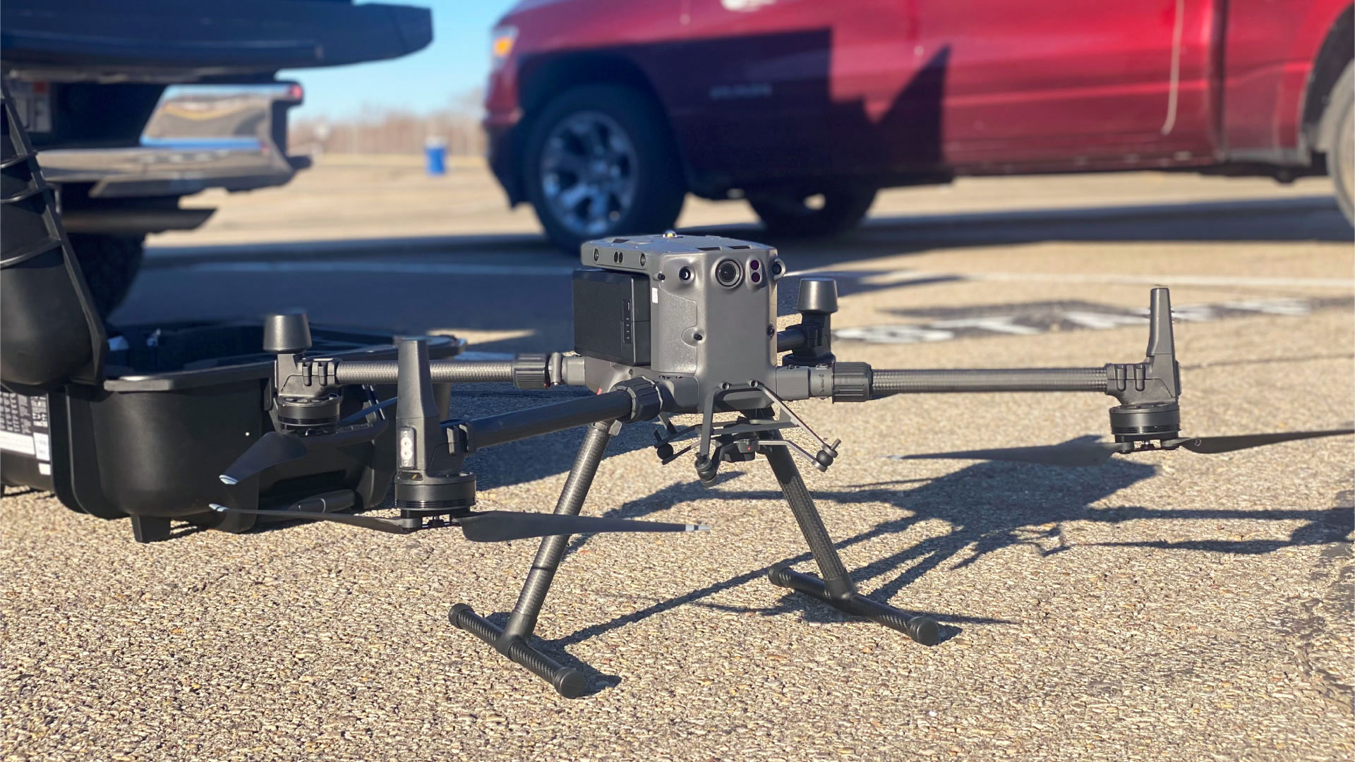
This year, we added the DJI Matrice 300 RTK commercial drone to our list of advanced survey equipment. This drone offers up to 55 minutes of flight time, 15 km transmission range and more, which enhances our abilities to collect data and measurements for different types of surveys.
The benefits of drone surveying
Using a UAS (an unmanned aerial system, or drone) for 3D mapping provides many benefits to a project. A UAS can capture aerial images and LiDAR from the sky. This equipment can be used to perform photogrammetry, topographic surveys and more.
- Reduces field time: Using a drone allows surveyors to conduct surveys over a large area of land in a shorter amount of time.
- Provides accurate data: Drones can take highly accurate measurements and photograph while collecting GNSS (Global Navigation Satellite System) data to map geographic locations.
- Can access hard-to-reach areas: A drone may be able to survey an area that would be difficult to access for a surveyor on land, which can further reduce time and increase safety for the surveyor.
A drone can also collect many different types of information that are beneficial to a surveyor, client and project. Types of information that can be collected by drone:
- Topographic Surveys: A topographic survey locates three-dimensional surface features of a property.
- Photogrammetry: Photogrammetry is the act of obtaining information from photos. Using images from a drone, individuals could create detailed maps or 3D reconstructions of buildings or sites. Detailed models and maps of an area can be created from these images.
- LiDAR: LiDAR stands for “light detection and ranging.” LiDAR sensors send out pulses of laser light and measures the time it takes for the light to return as they bounce off the ground. A point is created at every return the LiDAR sensor receives. This creates a point cloud of the area surveyed. A point cloud is millions of points that create a 3D model of the area.
How the drone improves land surveying
Drone surveying provides many benefits, such as the opportunity for faster, more accurate data. Using a drone improves our survey department’s efficiency; reduces costs for our clients; and allows us to provide accurate deliverables for projects.
There are different potential applications of a survey drone, which allows our firm to use this technology in a versatile way on a variety of projects:
- Land surveying: Drones collect accurate data quickly, providing information for things like cadastral and topographic surveys.
- Urban planning: Data from a drone can help create 2D and 3D models that integrate with local Geographic Information Systems (GIS).
- AEC: In the Architecture, Engineering and Construction (AEC) industry, drones can provide information before, during and after a project in the planning, progress and completion phases.
- Natural resource management: Drones can create detailed surveys of natural resources, like maps and models.
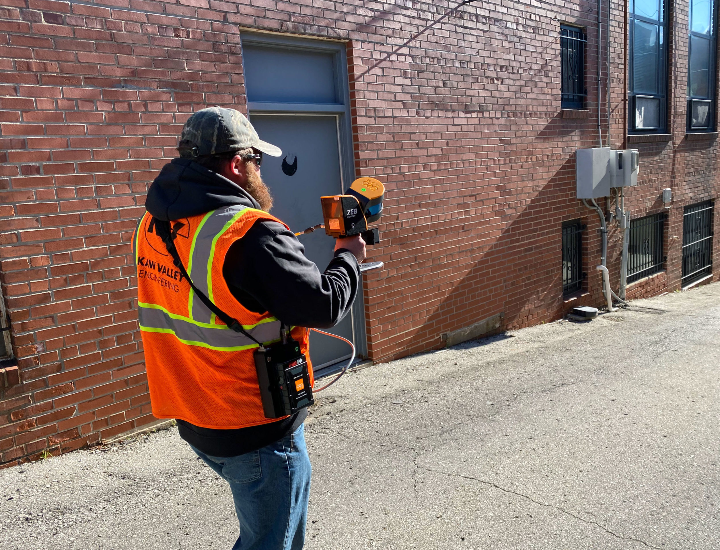
Handheld Scanning
In addition to our survey department’s new drone, our surveyors now have the capability to conduct a survey as they move, using the GeoSLAM Zeb Horizon Handheld Laser Scanner. This handheld scanner allows us to collect data quickly and in the most unique locations, expanding the services we provide to clients.
Features
- The Zeb Horizon scanner collects thousands of points per second and can be used in a variety of environments such as outdoor, indoor or underground environments.
- Surveyors can create a map of a location as they walk around, collecting 300,000 points per second with a range up to 100 meters.
- The handheld Zeb Horizon scanner is lightweight, capturing data quickly and easily.
One of our survey crews recently used this instrument to map a block near downtown Kansas City, Missouri. This tool was useful for this unique environment because the surveyor could walk down the sidewalks and alleys, collecting points bouncing from the nearby buildings.
Keeping up to date on the latest equipment and technology in land surveying helps our surveyors on a wide range of projects. A UAS and handheld laser scanner are two forms of survey equipment that can help improve capabilities for many projects.
We continuously use advanced survey technology to provide the most accurate, timely and cost-effective services to our clients. For more information about our survey services, please click here.
Since 1982, Kaw Valley Engineering has been the team of experts needed to help take a project from inception to completion, providing a full range of civil engineering, geotechnical engineering, surveying, construction observation and materials testing services throughout the Midwest. Our firm has offices in Junction City, Lenexa, Salina, Emporia, and Wichita, Kansas; and Kansas City, Missouri.